|
Funded
in part by
NSF grant 0538333
|
|
| Supplementary
material accompanying publication of paper in Science magazine, |
|
"Deformation
and Slip Along the Sunda Megathrust in the Great 2005 Nias-Simeulue
Earthquake" |
Caltech
media release (online)
Caltech
media release (pdf  ) ) |
|
|
 |
Click
on map and photos to enlarge.
*Having 'block pop-up
windows' enabled in your browser may prevent
this function. |
Caltech
geologists surveying coral heads uplifted 0.74 m (2.4
feet) by the 2005 Sunda megathrust rupture, on Bangkaru
island, west of Sumatra, Indonesia
photo: Danny Natawidjaja |
|
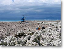
Caltech
and LIPI (Indonesian Institute of Sciences) geologists
surveyed coral reefs that were uplifted nearly 3 m
(nearly 10 feet) during the March 2005 megathrust rupture.
photo: Rich Briggs |
 |
Caltech
geologist John Galetzka surveying a newly formed beach
ridge on the outer edge of a coral reef uplifted 1.74
m (5.7 feet) in the Hinako islands, west of Nias island,
Indonesia
photo: Rich Briggs |
|
Children atop coral uplifted 1.74 m (5.7 feet)in
the Hinako islands, west of Nias island, Indonesia
photo: Rich
Briggs
|
|
Coral
heads uplifted 1.81 m (5.9 feet) on Hilimakora island,
north of Nias island, Indonesia
photo: Danny Natawidjaja
|
|
|
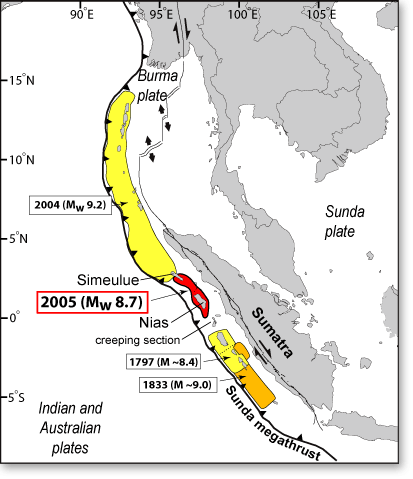
| A
mere three months after the giant Sumatra-Andaman earthquake
and tsunami of December 2004, tragedy struck again when
another great earthquake (shown in red) shook the area
directly to the south, killing over two thousand Indonesians.
The Mw 8.7 Nias-Simeulue earthquake just over a year
ago was one of the most powerful earthquakes ever recorded:
only six others have had greater magnitudes.
A team from the California Institute of Technology,
the Indonesian Institute of Sciences (LIPI), and Scripps
Institution of Oceanography reconstruct the fault rupture
that caused the 28 March 2005 event from detailed measurements
of ground displacements. Their analysis illuminates
the pattern and magnitude of fault slip, the relationship
between the 2004 and 2005 ruptures, and the surface
deformation that is likely to accompany future megathrust
rupture south of the equator. |
| PowerPoint® presentation |
 29MB 29MB |
 |
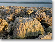
Spectacular
uplift of coral reefs due to megathrust rupture in
March, 2005 along the Hinako islands, west of Nias,
Indonesia
photo: Aron Meltzner |
|
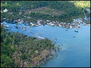 |
Some
places subsided during megathrust rupture: The village
of Haloban in the Banyak islands sank 0.62 m (2.0 feet)
photo: Danny Natawidjaja |
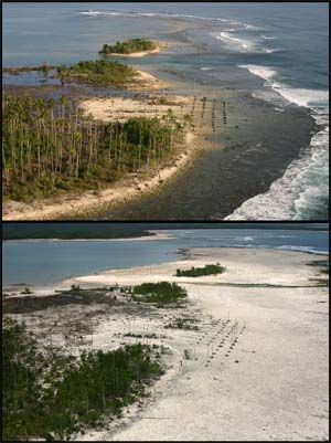 |
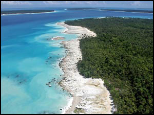
Before
the March 2005 earthquake, the southwestern coast of
Nias island was slowly subsiding, as evidenced here
by a stand of dead coconut palms seaward of the beach (upper
photo). During the earthquake, the coast rose
about 2.5 m, elevating the dead grove and neighboring
coral reef out of the surf zone and re-uniting the
small islands in the background with the mainland of
Nias island.
photos: Kerry Sieh |
|
| |
|
California Institute of Technology,
Tectonics Observatory MC 100-23, 1200 E. California Blvd. Pasadena
CA 91125
|
|
|
|