|
While it is commonly thought that the geometry of an earthquake fault is more complicated on the surface of the Earth than at depth, this new study reveals just the opposite for the particular case of Mexico's 2010 Baja California earthquake.
At the surface, the 120 km fault trace is surprisingly straight, cutting through the Colorado River delta and the rugged topography of the Sierra Cucapah mountains. Thus one might expect the fault to continue vertically down from this trace.
Yet this study shows that at depth, several faults ruptured and those faults were not vertical. Rather, they tilted at various angles.
In fact, the seismic rupture began on one fault, then spread bi-laterally toward the northwest and southeast along two other faults that each dipped at different angles.
Thus we conclude that measurements of surface deformation alone are not enough to anticipate the location and extent of an earthquake rupture.
To produce such a high-resolution model of the earthquake (which describes not only the geometry of the faults that broke during the quake, but the time evolution of the rupture as well), we used data from both remote sensing techniques (which measure surface displacement based on radar and optical images) and seismological techniques (measurements as well as models of the ground vibrations generated by the earthquake).
|
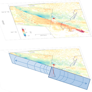
Map showing (upper panel) the north-south displacement of the Earth's surface during the earthquake, as well as (lower panel) the complex geometry of the underlying faults that ruptured. The red star indicates the epicenter. Surface colors indicate the amount and direction of surface displacement, blue being southward motion, red northward. In the upper panel, a clear asymmetry is seen in the distribution of strain on either side of the epicenter. This image is obtained from subpixel correlation of optical and SAR images. The lower panel shows model results of the underlying ruptured faults. An unexpectedly complex geometry is seen: rather than one vertical fault running the length of the rupture, two main faults are seen, each tilted away from the vertical in opposite directions from one another. The fault running northwest from the epicenter is tilted toward the Mexicali Valley, while the fault running southeast is tilted away. CREDIT: Anthony Sladen, Geoazur
|
|
